Tuesday, 30 July 2013

Pennine Walk. Day4.


Another beautiful day and I head down to Thwaite in Swaledale.

I'm so busy being annoyed with  the constant signs to keep to the path and walk in single file through the field that I head off down the valley for 10 minutes before doubling back to head up and over to Keld.


I arrive at a quiet time at the tea room.  10 minutes later and theres a big queue out of the door as cars full of  folk arrive.


Theres now a long slog up to Tan Hill.  I wear a hat and long sleeves so the only bit of skin consistently in the sun is the back of my hands.  They getting  sore  so I wear my spare socks as gloves.

A pint of lime and lemon, some chips and a panini a bit of a rest and I gaze out on the vastness that is Bowes Moor.

I'm glad I don't have to cross this in the mist.  I still find it an eerie place, no sign of crows, buzzards, peewits curlews or any thing.  But lots of grouse feeding stations.  Half way across I see a distant 4 wheel drive on a ridge and I'm sure they are watching me.
Eventually God's Bridge and the A66 appear. Got to cross the moor on the other side of the road.  A likely water source / camp in Deepdale.


I camp near a little gill below the horizon above the shed.  I was ready for the cup of tea.
20 miles walked.


Monday, 29 July 2013

Pennine Walk. Day3.


Up at the crack of dawn again I'm porridge powered into Hawes.  A second breakfast and an ice cream the I'm heading across the fields to Hardrow.


The path then heads up the ridge to Great Shunner Fell.  I am very sweaty and do a left and bushwack into the valley bottom for a bath and a clothes washing session.


This turns out to be a fenced off area where they have excluded sheep.  There are loads of rabbits in the lush grass.  Peewits and curlews on the slopes and for the first time I see a buzzard.


More bushwacking back to the path and Great Shunner summit appears.


I drop off the other side and get the tent up.  The phone is going flat as I've had runkeeper running all day, so I plug it into the solar panel.  Despite being heavy I brought the power monkey battery as well.  I've got the Kindle and GPS to keep charged.  Unfortunately the battery despite being fully charged developed a fault  and wouldn't switch to supply.  Had to bin it when I got home.
Just got the tea cooked before the wind dropped and the midges went crazy.


15  miles walked. 2 ice creams, 1 scone, 1 full english.

Wednesday, 24 July 2013

Pennines. Day2.


Up at the crack of dawn and  over the summit of Fountain's Fell. A bit of a loop round to the end of Pen y Ghent.


This was the most popular hill by far as a lot of 3 peakers were coming up from Horton.

The way ahead on the white path.  It swings off to the left down to Horton.  Then it goes up the valley to the right in the distance.  One of the peculiarities I noticed was how the route does a big loop out to somewhere then back again.
It was worth it for the Pen y Ghent caf.


The guidebook I was using said there's a shop, but it was shut down.
Did I mention the clegs?  The next few miles were farmy and clegy.


Water was a problem in the farmland and even the above beck on closer inspection didn't tempt me.
I only have aqua mira drops and this water was the colour of wee.

Eventually I found an ice cold spring on Cam End and a suitable hollow to pitch the tent.

15 miles walked.


Monday, 22 July 2013

Pennines, Day 1


I caught the train from Carlisle to Lancaster and after a coffee and bacon sandwich on Lancaster station I caught the train with "trouble at t'mill accents" to Gargrave.
A quick visit to the coop for some matches and crackers and I'm heading for Mallam.


The walk is besides the Rivber Aire.  It's hot and it's cleg heaven.  At last I reach Mallam and food and a pot of tea.  This will be a pattern. Cafes for second breakfasts and dinner.  Tea later on in tent.  It saves weight you know.


The Way leads up the side of the Cove.  It's very busy.  I press on and luckily there's a ice-cream van at the car park before Mallam Tarn.  A 99 and a bottle of icy water boost me onwards as I plan to camp above the intakes.


Fountains Fell on the left the target.


Tent up, air the bag. get the tea cooking.   View back to Mallam Tarn.


.Impressions of this section:  A bit farmy, very overgrazed, lots of clegs.  Brilliant weather.
I walk over the ridge to view the route ahead tomorrow, over Pen y Ghent.

15 miles walked.

Monday, 13 May 2013

The Tebay Lad and Geordie Lass Relax on Beach


We had previously done a cycle tour in Andalucia  and decided on  a week's holiday in the sun.  After seeing Mceff's blog about the Sierra Nevada   (  http://becausetheyrethere.com/2012/10/04/lucero-where-old-hatreds-linger/#more-5195)  we ended up in the Hotel Alcadema in Lanjaron.


Monday we headed for the trail head below the Cuerda del Travenque ridge.


The city in the background is Granada.


The heat was reflected by the white limestone scree but we had 4 litres of water between us.


We round a bend and the hill seems a long way off,  it's the Cerro del Trevenque 2083m.


We alternate between the ridge and a broad path just below the crest.


A local bloke with his dog overtakes us as we head up the steep bit for the summit.


At last the summit with the high Sierra beyond and a baguette to chomp.


We had come up on the right of the picture and are going to descend the white scarred ridge in the centre and then down the waterless valley , over the col and back to the car.


This is a good way down as the river bed is dry and easy to walk on.


So the relaxing on the beach........

The day after the walk we had a day at the coast.  I took my shirt off to dazzle the onlookers and managed 10 minutes on this rock.  We then had a paddle and headed for the hills.  I know everyone is different but we passed some sun beds with brown prune like bodies lying on them.  How the hell anyone can just lie there for hour after hour is a mystery.


Sunday, 28 April 2013

Borrowdale Pink Rock


After a mad dash after work and a call to Penrith Morrisons I park the car outside my mam and dads at 20:15.  That'll give me just over an hours daylight to reach Borrowdale, climb the  Whinfell ridge and get the tent up. Borrowdale is a side valley going right in the above picture just below the snowy fell.


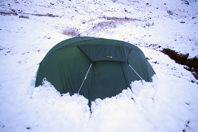
I got the tent up at 22:00.  I carry 4 litres of water up from the beck and get the tent in the lea of a wall.
I brew coffee in the morning and the snow is already melting.


Daylight and I'm glad of that wall as the wind is strong.  I aim to walk along the ridge in the left of the picture and come back down the valley.  There's a couple of things I want to see.  If you look at Whinfell Beacon from the south there is a wood very near the top.  Wainwright reckons this was planted to provide wood for the beacon.  I'm on a mission to check it out.  There's the mystery of the pink rock.  I used to fish this valley 40 yrs ago and remember seeing pink rocks in the beck that weren't Shap Granite and certainly not the silurian mud stones of the local geology.


The wood is beautiful, the trees old and twisted.  Someone went to a lot of trouble as there is the remains of a drystone wall all the way around. The trees are not regenerating as sheep are in there now.
How long ago where beacons used ?  Are these trees that old?  They are only a short walk from the summit.


Back on the ridge I look back at the way I've come.  I'd camped just to the left of the far radar aerial.


Eventually I reach the A6  and do a sharp right back down the valley. 


Not far from here is where we once had a youth club barbecue.  One of the lads pulled a big salmon out of the beck and took it home for his mam. 


When  I sit by the beck for lunch I look for the pink stones.  They are visible in the photo above.
I hadn't imagined it, but the mystery remains they are dark pink but dont have the big crystals of the Shap Granite.  They are heavy and very tough to break.  More research needed.


It's just a question of heading over the ridge to Roundthwaite and then on to Tebay.


Just for a change it looks like rain in Tebay.  I can see my mam and dad's house from here.


Lune valley and Howgills behind.


Coming down to Roundthwaite with Tebay behind.  Just the motorway and railway to get through.


  I can remember before this was built.
Further on there are fences where there never used to be and the  little streams where the sticklebacks were are gone.  There used to be ponds near the river with newts in, no sign. There were reads next to the bridge with water rats,  just grass and trees now.


The street above used to have a cake shop and cafe, a post office, a coop,  an electrical shop and a drapery and I knew everybody's name.
Mind you they do have street lights now and indoor toilets.